map 1
Saudi Arabia is located in the Middle East which is the area of southwest Asia. Saudi Arabia occupies most of the Arabian Peninsula.
It is in extreme southwest Asia, on the Arabian Peninsula along with Iraq, Jordan, Yemen, Oman, the United Arab Emirates, Qatar and Kuwait.
 (870,000 sq mi), constituting the bulk of the Arabian Peninsula) and the second-largest in the Arab world (after Algeria). It is bordered by Jordanand Iraq to the north, Kuwait to the northeast, Qatar, Bahrain and the United Arab Emirates to the east, Oman to the southeast,Yemen in the south, the Red Sea to the west and Persian Gulf to the east. Its population is estimated to consist of 16 million citizens and an additional 9 million registered foreign expatriates and 2 million illegal immigrants.
F
Saudi Arabia officially known as the Kingdom of Saudi Arabia (Arabic: المملكة العربية السعودية al-Mamlakah al-‘Arabiyyah as-Su‘ūdiyyah, is the largest Arab state in Western Asia by land area (approximately 2,250,000 km2
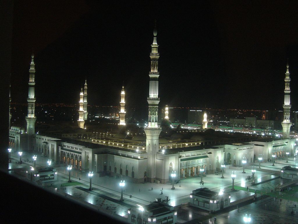
The Kingdom of Saudi Arabia was founded by Abdul-Aziz bin Saud (known for most of his career as Ibn Saud) in 1932, although the conquests which eventually led to the creation of the Kingdom began in 1902 when he captured Riyadh, the ancestral home of his family, the House of Saud, referred to in Arabic as Al Saud. The Saudi Arabian government, has been an absolute monarchy since its inception, and it describes itself as being Islamic. Saudi Arabia is the birthplace of Islam and the kingdom is sometimes called "the Land of the Two Holy Mosques" in reference to Al-Masjid al-Haram (in Mecca), and Al-Masjid al-Nabawi(in Medina), the two holiest places in Islam.
Jeddah

- Terrain
Saudi Arabia covers approximately four fifths of the area of the Arabian Peninsula, which can be described as a rectangular plateau gradually sloping eastwards till reaching sea level at the Persian Gulf.
The main topographical features are as follows:
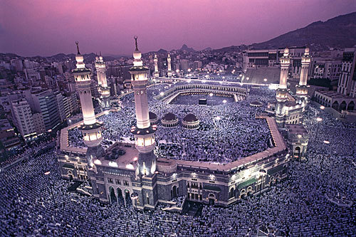
The Sarawat or Sarat mountain range runs parallel to the Red Sea coast beginning near the Jordanian border until the southern coast of Yemen, gradually increasing in height southwards. It is largely made up of barren volcanic rock, especially in the south, and sandstone in the north, but it is also interspersed with ancient lava fields and fertile valleys. As one moves further south towards Yemen, the barren landscape gradually gives way to green mountains and even woodlands, the result of being in the range of the monsoons. In Saudi Arabia, the range is commonly known as the Hejaz, though the southernmost part of the range is known as 'Aseer. In the foothills of the Hejaz lies the holy city of Makkah, and approximately 400 km north of Makkah in an oasis between two large lava fields lies the other holy city of Madinah.

West of the Sarawat or Hejaz mountain range is a narrow coastal plain known as Tihama, in which the country's second largest city, Jidda, is located.
East of the Hejaz lies the elevated plateau known as Najd, a sparsely populated area of desert steppe dotted with small volcanic mountains. To the east of Najd-proper lies the Tuwaig escarpment, a narrow platau running 800 kms from north to south. Its top layer is made of limestone and bottom layer of sandstone. Historically rich in fresh groundwater and criscrossed with numerous dry riverbeds (wadis), the Tuwaig range and its immediate vicinity are dotted with a constellation of towns and villages. In the middle, nestled between a group of wadis, is the capital city, Ar-Riyadh.
Further east from the Tuwaig plataeu and parallel to it is a narrow (20-100 km) corridor of red sand dunes known as the Dahana desert, which separates the "Central Region" or "Najd" from the Eastern Province. The heavy presence of iron oxides gives the sand its distinctive red appearance. The Dahana desert connects two large "seas" of sand dunes. The northern one is known as the Nufuud, approximately the size of Lake Superior, and the southern is known as "the Empty Quarter," so-called because it covers a quarter of the area of the Peninsula. Though essentially uninhabitable, the edges of these three "seas of sand" make for excellent pastures in the spring season, but even the bedouin almost never attempted to cross the Empty Quarter.
North of the Nufud desert lies a vaste desert steppe, traditionally populated mainly by nomadic bedouins with the exception of a few oasis such as Al-Jof. This region is an extension of the Iraqi and Syrian deserts (or vice versa). After a rainy season, these barren, rocky steppes can yield lush meadows and rich pastures.

The eastern province is largely barren except that it contains two oases resulting from springs of ancient fossil water. These are the oases of Al-Qateef on the Gulf coast and Al-Hasa (or Al-Ahsa) further inland. Next to Qatif lies the modern metropolitan area of Dammam, Dhahran and Al-Khobar.
- Elevation extremes
- lowest point: Arabian Gulf 0 m (0 ft)
highest point: Jabal Sawda' 3,133 m (10,279 ft) - Natural resources
- petroleum, natural gas, iron ore, gold, copper
- Land use
- arable land: 1.72%
permanent crops: 0.06%
other: 98.22% (1998 est.)

[edit]Climate
People tend to think of Saudi Arabia as an expanse of scorchingly hot desert punctuated with oil wells, and for most of the time in most of the country, they would be absolutely right. From May to September, the country (basically everything except the southwestern mountains) bakes in temperatures that average 42°C and regularly exceed 50°C in the shade. In July and August, in particular, all who can flee the country and work slows down to a crawl. The coasts are only slightly moderated by the sea, which usually keeps temperatures below 38°C — but at the price of extreme humidity (85-100%), which many find even more uncomfortable than the dry heat of the interior, especially at night. Only the elevated mountainous regions stay cool(er), with the summer resort city of Taif rarely topping 35°C and the mountainous Asir region cooler yet.

In winter, though, it's a surprisingly different story. Daytime highs in Riyadh in December average only 21°C, and temperatures can easily fall below zero at night, occasionally even resulting in a sprinkling of snow in the southern mountains# The winter can also bring rains to all or most of the country, although in many years this is limited to one or two torrential outbursts# The end of spring #April and May# is also a rainy season for much of the country# In the south, though, this pattern is reversed, with most rain falling during the Indian Ocean's monsoon season between May and October#

Saudi Arabia has the world's second largest oil reserves which are concentrated largely in the Eastern Province. Oil accounts for more than 95% of exports and 70% of government revenue, although the share of the non-oil economy has been growing recently. This has facilitated the transformation of an

underdeveloped desert kingdom into one of the world's wealthiest nations. Vast oil revenues have permitted rapid modernisation, such as the creation of a welfare state. It has also the world'ssixth largest natural gas reserves. It is the only country in the world where women are not allowed to driv
No comments:
Post a Comment